Friday, December 17, 2010
Civil War Historical Roadside Marker: Old Holly Creek P.O. (105-1B)
N 34º 39.809 W 084º 49.722
Highway 225
Murray County, Georgia
Old Holly Creek P.O.
May 16, 1864. Brig. Gen. J.D. Cox’s Div., 23d A.C. (USA) having crossed the Conasauga River at Hogan’s Ford, 2 mi. S. of Tilton, camped at or near Holly Creek P.O., in this vicinity.
May 17. Learning that the 20th Corps troops (USA) had usurped the Coosawattee River crossing at McClure’s Ferry (at Pine Chapel), Cox moved his troops (via AUDUBON crossroads) to Field’s Mill – two miles above McClure’s, where they were joined by the other two divisions.
The 23d A.C. was the left flank of Sherman’s army, enroute S. in pursuit of the Confederate army retreating from the battlefield of Resaca after two days of battle.
Date Visited: July 24, 2008
Saturday, September 25, 2010
Yondering Into Murray County
Thursday, September 16, 2010
Civil War Historical Roadside Marker: Snake Creek Gap (064-8)

Tuesday, June 22, 2010
Father's Day Yondering Trip

Father’s Day Yondering Trip - June 20, 2010
After a Father’s Day breakfast provided by my loving family via the Resaca Hardees I was given the opportunity to take a little geocaching trip. Unfortunately I could not find my GPS. I fear that it may be a causality of the move. Time will tell. I grabbed my notebooks and a compass and took off toward Sugar Valley, Georgia. In Sugar Valley I crossed Horn Mountain on the Pocket Road and stopped off at Fowler Cemetery. This is a hillside cemetery of some size. I did not find in marked Confederates, but I did find a Dough Boy that died in 1918. I left the cemetery and headed north up through the Chattahoochee National Forest. Just south of Furnace Creek and Furnace Creek Road I spotted a small cemetery in a clearing west of the road. This is an area that appears to be recently cleared off. After visiting three graves I was walking back and noticed a bone jutting up out of the ground. It was appears to be a bleached tibia…much larger and robust than a dog or deer. It truthfully appeared to be human in nature. I left it leaning against a tree and headed north on the Pocket Road.
In Villanow I struck out north along Highway 201. Approximately three miles above Villanow I entered Whitfield County and encountered a historical marker in the parking lot of Salem Church. The sign was titled Geary’s Division to Dug Gap (155-8). Two miles farther north I stopped where Gordon Springs Road intersects 201. At this intersection there are two historical markers: Twentieth Corp in Dogwood Valley (155-7) and Callaway Place (155-29C). A local person told me that the original Callaway home is actually the brick home that

sets behind this marker. I photographed the house and the signs and bought a cold Diet Coke before driving north toward Rocky Face. In Rocky Face 201 intersects with Highway 41 – The Old Dixie Highway.
I turned north on 41 a drove for Tunnel Hill and then on into Catoosa County. I visited the Ebenezer Baptist Church just east of I-75. This church contains the marked graves of several local Confederates. There is also an area of the cemetery were a number unknown Confederate dead are buried. I stayed on 41 and drove on through Ringgold Gap into town.
In Ringgold I made several stops. I started at the Anderson Cemetery over near the interstate. Here is another site in which unknown Confederate dead are interred. These warriors of another time are spending their eternity behind an oversized wooden wall that blocks their view of neon glow of commercialized Ringgold. Historical markers were encountered at several locations

throughout town. In front of the Catoosa County Court House stands Catoosa County (023-1) and Confederate Hospitals (23-14). At the corner of Tennessee Street and High Street stands the impressive two story Whitman House. The historical maker Whitman House (23-10) mentions that the battle at the Ringgold Depot was observed by the residents of the house from the second story windows. The Depot itself is the site of another maker: Western& Atlantic Depot (23-8). Leaving Ringgold heading south on 41, I stopped at the Atlanta Campaign Pavilion. I have also photographed the pavilions at Cassville, Resaca, and Dalton. The historical marker Ringgold Gap (23-16) tells the story of the stubborn defense of the Confederate rear given by GeneralPatrick Cleburne’s troops in the Gap. There is also a statue of this fiery Confederate at the pavilion. His bronze eyes seem to shoot bolts of fire….
A few miles south of Ringgold Highway 2 splits off and 201 goes toward Varnell. In the forks of the road stands the Old Stone Presbyt
erian Church. It is a local history museum that appeared to have just closed. In its yard is a historical marker – Old Stone Presbyterian Church (023-9). There is also a large plaque commemorating the Trail of Tears in the parking lot. Opposite the church along the side of Highway 2 is another historical marker: Old Federal Road (023-7). Up behind the church was a very old cemetery. This cemetery contained quite a few individuals that were born in the seventeen hundreds. I would suppose these were the first settlers venturing down the Federal Road and finding their way into the new interior. It is interesting the overall size of the cleared area. Below the active part of the cemetery is a grass slope that contains as much space as the cemetery proper. I wonder if there are unmarked graves on that slope. The Stone Church was used as a hospital…could there be unmarked Confederates or Union soldiers resting on that grassy slope? That is question that begs more research!
Heading east toward Varnell on the Highway 2…the Catoosa Parkway… I visited Lee Chapel. About three miles below the Rock Church I documented a sign located in the intersection of Highway 2 and Tunnel Hill Road. The sign is titled Campaign for Atlanta Began Here (23-4). In understand Sherman observed his troops moving east from Ringgold from the Lee Home to the north. From this point I continued eastward in Whitfield County for two miles to Varnell. Coming into this town one passes over an elevation known at the Cohutta Ridge. This ridge appears to be a northern extension of Rocky Face and it gives one a view of the mountains east of Dalton. In Varnell I visited a house known as the Varnell Home. In the yard there is a historical marker: Varnell Home ( 155-32). Directly opposite this house is a place called Varnell Spring Branch. I watched a family fill many jugs of the water from this spring…for home use I supposed. Leaving Varnell 201 tracks to the south and west toward Tunnel Hill. Here I visited the Foster Cemetery and noted several Confederate soldiers.
It was getting late so I turned south out of Tunnel Hill. Stopped and got my last Diet Coke of the day and headed home! Thus ended a great Father Day’s gift of a yondering afternoon.
Monday, April 26, 2010
Appendage Burial

Henson Springs Cemetery
Lamar County, Alabama
N 34° 00.781 W088° 03.892
Date Visited: April 6, 2010
Sunday, March 21, 2010
World War I Solider: 2nd Lieutenant William L. LeConte
Eastview Cemetery
Adairsville, Bartow County, Georgia
N 34° 22.021 W084° 55.484
Date of Visit: February 27, 2010
Tombstone Inscription:
In Memoriam
Wm. Lewis LeConte
Killed in Action
Chateau Thierry France
Son of J.A. & Emma K Leconte

Sept 27, 1895
July 19, 1918
Discussion:
William Lewis LeConte was the son of James A. LeConte and Emma Kinman of Adairsville, Georgia. The descendent of the famous LeConte family of naturalist and scientist, LeConte was born in 1895. He was a graduate of the Boy’s High School (later to become Grady High School) and Emory University. At time of enlistment into the AEF he was employed in Atlanta with General Electric. After training at Camp Greene, North Carolina, LeConte was posted with the 59th Regiment of the 4th Division. On July 19, 1918 the 4th Division was sin the line of battle during the Aisne-Marne Operations. It is recorded that he died of his wounds on the 19th and was buried in Plat A, Row 7, Grave 29 in the Aisne-Marne American Cemetery in Belleau, France.
.
Sources:
Aisne-Marne American cemetery, American Battle Monumnbets Commission, www. abmc.gov, accessed March 15, 2010
125 Casualties Among Our Forces in France 21 Army Officers Dead and 8 Wounded, Special to The New York Times, August 1, 1918. http://query.nytimes.com/gst/abstract.html?res=9C0CEEDE1739E13ABC4A53DFBE668383609EDE, accessed March 20, 2010
William L. LeConte, Find A Grave Memorial #9210377, July 31, 2004
Sunday, March 14, 2010
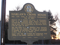
Civil War Historical Roadside Marker: Harlan’s Cross Roads (064-21)

Civil War Historical Roadside Marker: Harlan’s Cross Roads (064-21)
Location:
N 34º 34.851 W 084º 52.772
Intersection of Ga 225 and Pine Chapel Road.
Gordon County, Georgia
Harlin’s Cross Roads
Maj. Gen. John M. Schofield’s Headquarters May 16, 1864.
Hovey’s 1st & Judah’s 2d divs. of Schofield’s 23d A.C. (USA) enroute from Resaca battlefield crossed the Conasauga River at Fite’s Fy. intending to pass the Coosawattee at McClure’s Ferry, 1.25 mi. east of here. But the 20th A.C. (USA) diverted from Newtown Ferry by Gen. Hooker got ahead of Schofield & crossed at McClure’s . This forced Schofield's 2 div. 2 mi. S.E. to Field’s Fy.
Cox’s (3d) div. (USA) crossed the Conasauga near Tilton, & via Holley, marched to Field’s Fy.
Date Visited: 11/8/09
Friday, March 12, 2010
Civil War Historical Roadside Marker: Lay’s Ferry (64-12)

Location:
N 34º 32.458 W 084º 58.265
Intersection of Highway 136 Connector and Hall Memorial Road
Gordon County, Georgia
Lay’s Ferry
Lay’s or Tanner’s Ferry, Oostanaula River, was 1.5 mi. S.W. of this point – access road no longer existing.
May 14, 1864. Sweeny’s (2d) div. 16th A.C. (USA) moved to Lay’s Ferry & effected crossing by one brigade but a false rumor of Confederate crossing above caused the Federals to withdraw to this side.
May 15. Sweeny’s div. made the crossing. He was at once assailed by Walker’s div. of Hardee’s Corps (CSA) – an affair known as the battle of Lay’ Ferry. This move on Johnston’s left rear caused him to abandon position at Resaca and retreat south.
Date Visited: 11/22/09
Civil War Historical Roadside Marker: Field’s Mill & Ferry (64-23)

Location:
N 34º 33.871 W 084º 49.972
Owens Gin Road at Coosawattee River Bridge
Gordon County, Georgia
Field’s Mill & Ferry
May 16, 1864. Butterfield’s (3d) division., 20 A.C. (USA) instead of crossing at McClure’s Ferry 2 mi. downstream, sought to gain time by moving to Field’s - - reaching here 11 P.M. Not until noon of the 17th was it across.
Schofield, prevented from crossing his corps (23d) (USA) at McClure’s moved the 1st and 2d divs. to Field’s, arriving here early the 17th - - as did Cox’s (3d) div., which marched via Tilton & Holley.
With Butterfield at Field’s, Schofield’s A.C. (the left wing of Sherman’s advance from Resaca), was held up 24 hrs. because of the erratic moves of the 20th Corps.
Date Visited: 11/8/09
Sunday, February 7, 2010
The Move to Adairsville
About Me
- Greg Green
- Calhoun, Georgia
- I have a new blog at Wordpress called Notes from the Field. A great deal of information collected on trips to cemeteries will be written about Notes from the Field.


